EARTH’S SATELLITE LAYER, COMPLEXITY INVERSION AND RISE OF ORBITAL WARFARE
This page looks at Orbital Warfare arising from two trends. The first trend was the notion that U.S. and Soviet satellites in Earth Orbit could potentially fight each other. The second trend was the Earth would develop around it a permanent Human-made artificial layer of satellites that increase in density, and strategic significance, such that satellite need to be defended from potential attack, which could come from an opponent orbiting craft.
1978 COMPLEXITY INVERSION THEORY
In 1978 an Advanced Systems Project Manager in Rockwell International Corporation’s Space Division proposed the notion of, “Complexity Inversion” in relation to creating a Space-Based Information Infrastructure [Gould, C.L. 1978 Large Scale Human Benefits from the Industrialization of Space. The 15th Space Congress. Proceedings]. Complexity Inversion is where initially the bulk of a system at its Space-End is small and light. The corresponding Ground Segments are massive and complex. Advances in technology, and keeping within reasonable launch cost limitations, the reverse of this situation becomes feasible to make the Space Segment vastly more capable and complex. Since the 1970s a critical transition has taken place, where around Earth has developed a permanent Human-made artificial layer of satellites, that have increased in number, and strategic significance. There are two types of Complexity Inversion into Space Orbit:
Replacing or replicating in Orbital Space and equivalent system found on the Earth’s surface, such as a communications system, and rather than rely on ground units to broadcast a signal this is done by a satellite broadcasting down to the Earth’s surface to be received and used.
Putting into Orbital Space a satellite, carrying ground surveillance or survey technology and relying on this, rather than Ground-Based, or air transported versions.
In both cases, what has occurred is that ‘the technology’, a particular Human activity is dependent, is no longer found on the Ground Surface (Segment), it has been placed in the Space Segment, and the only technology remaining on the Ground is that used to connect, or receive information from.
EARTH’S SATELLITE LAYER AS SPACE GEOGRAPHY
The Earth’s Satellite Layer can be viewed in terms of Space Geography, composed of Human-made objects that maintain a stable orbit around the Earth. Earth’s Satellite Layer is both replenished with regular Space Launching activity, and loses matter in terms of Orbital Debris deorbiting into the Earth’s atmosphere. However, rather than remaining a constant Layer, it is in fact growing in density as more satellites are put into Orbit, to replace defunct ones, and to add greater complexity.
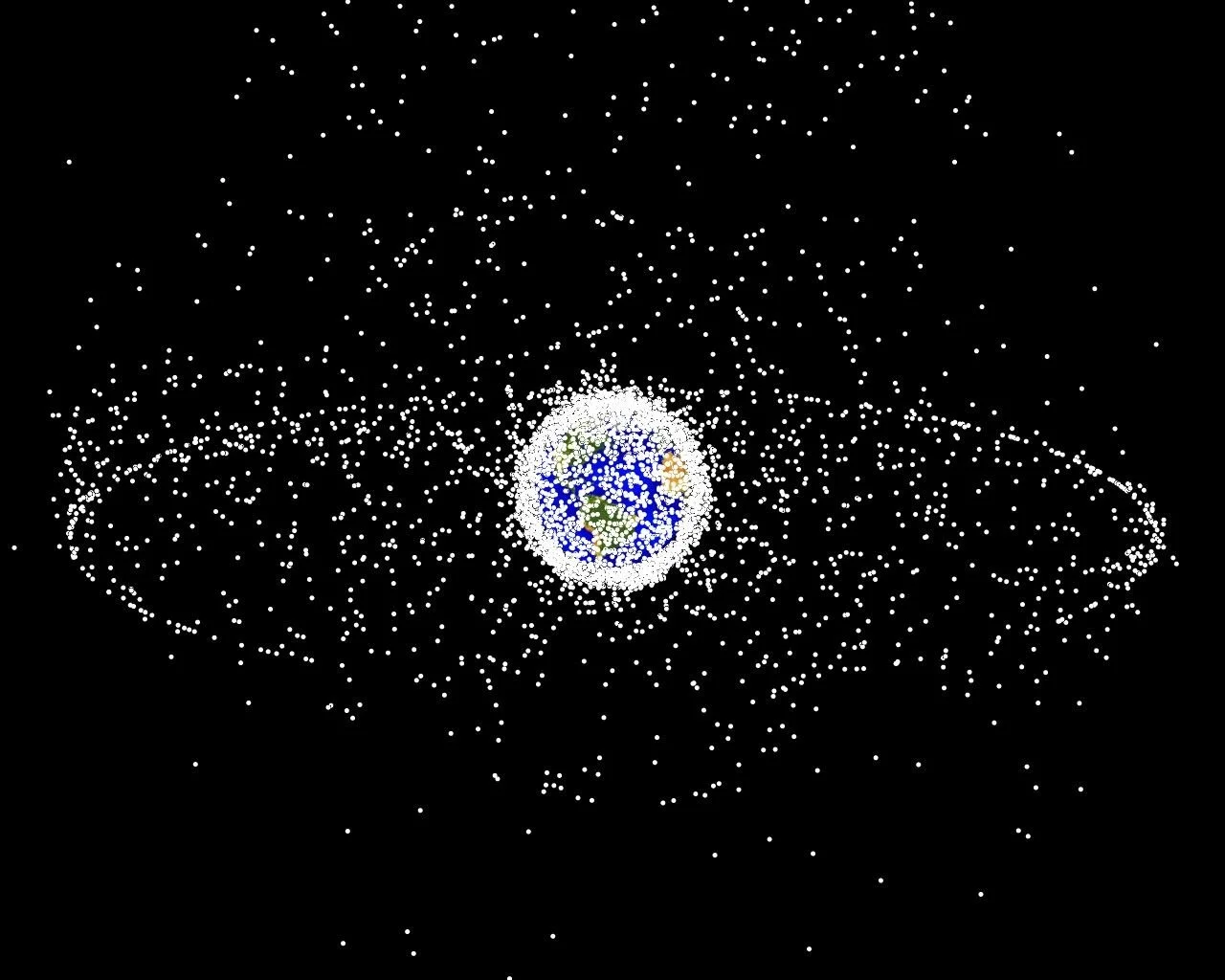
► A well-known NASA image from its NASA Orbital Debris Program Office Photo Gallery showing computer-generated image of objects (functional satellites and orbital debris). Dots represent current location of each item. The orbital debris dots are scaled according to the image size of the graphic to optimize their visibility and are not scaled to Earth.
‘As can be seen, the Satellite Layer has become a defined spherical structure around the planet. This phenomenon has been growing since the start of the Space Age.’
Viewed in terms of Space Geography, the Earth Satellite Layer is notionally part of a much larger system of ‘Space Transit Lines’ composed of, “lanes of commerce and military lines of communications in Space” [Dolman, E.C. 2002 Astropolitik: Classical Geopolitics in the Space Age. Frank Cass]. Space Transit Lines are crucially connected, “[to] … Hohmann Transfer Orbits between stable Spaceports.” [Dolman, 2002] In orbital mechanics, Hohmann Transfer Orbits: an elliptical orbit used by a craft to transfer between two circular orbits of different radii around a central body in the same plane. The Hohmann Transfer often uses the lowest possible amount of propellant in traveling between orbits,
“because of gravity wells and the forbidding cost of getting fuel to orbit, over time Spacefaring nations will develop specific pathways of heaviest traffic. Each of these pathways, identified later in the Astropolitical model as Hohmann Transfer Orbits, can be shown to have or to be in themselves critical chokepoints. The state that most efficiently occupies or controls these positions can ensure for itself domination of Space commerce and, ultimately, terrestrial politics.” [Dolman, 2002]
The Satellite Layer that has become a defined spherical structure around the planet, is a phenomenon that has been growing since the start of the Space Age. It is a mass of Low, Medium, and High Earth Orbits of working satellites, the Space Stations (International Space Station and Tiangong), and Space Junk that permanently circumnavigates our planet, not unlike Saturn’s rings. The Satellite Layer has become a central piece of strategic geography in Space, in the same way that Astropolitics currently identifies favoured orbits, orbital flight paths, transfer orbits, gravity wells, and the Lagrange Points as the strategic geography of Space.
ORBITAL WARFARE AND THE SATELLITE LAYER
Existence of the Earth Satellite Layer changes one of the fundamentals of Orbital Warfare as it was originally conceived in the Post-WW2 era. Namely, opponent military craft in orbital Space would attempt to destroy each other, in an extension of Ground-Based craft in land, sea or air battle. Transition into Space-Based Systems leads to the requirement for there to be a force of guardian craft to protect critical satellites, and the optimum orbital paths these occupy as critical military lines.
KEY POINTS ABOUT ORBITAL WARFARE
Complexity Inversion, Satellite Layer, Space Geography.

